
Târgu Bujor topographic map
Interactive map
Click on the map to display elevation.
About this map
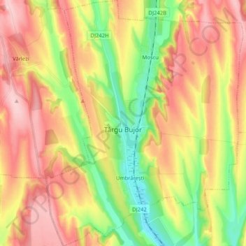
Name: Târgu Bujor topographic map, elevation, terrain.
Location: Târgu Bujor, Galați, Romania (45.81748 27.86396 45.92783 27.99120)
Average elevation: 128 m
Minimum elevation: 26 m
Maximum elevation: 227 m
Other topographic maps
Click on a map to view its topography, its elevation and its terrain.
Costache Negri
Romania > Galați > Costache Negri
Costache Negri, Galați, 807095, Romania
Average elevation: 69 m