
Mâatkas topographic map
Interactive map
Click on the map to display elevation.
About this map
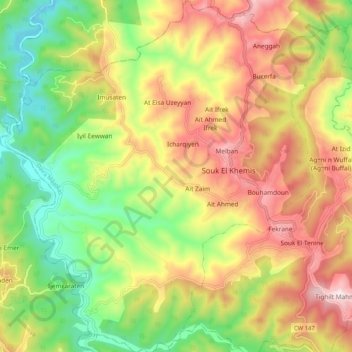
Name: Mâatkas topographic map, elevation, terrain.
Location: Mâatkas, Daïra Mâatkas, Tizi Ouzou, Algérie (36.56918 3.91837 36.65231 4.01459)
Average elevation: 391 m
Minimum elevation: 87 m
Maximum elevation: 738 m
Other topographic maps
Click on a map to view its topography, its elevation and its terrain.
Aït Ahmed
Algérie > Tizi Ouzou > Daïra Mâatkas > Mâatkas > Aït Ahmed
Aït Ahmed, Mâatkas, Daïra Mâatkas, Tizi Ouzou, 15017, Algérie
Average elevation: 474 m