
Lordship topographic map
Interactive map
Click on the map to display elevation.
About this map
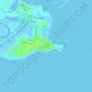
Name: Lordship topographic map, elevation, terrain.
Average elevation: 1 m
Minimum elevation: -7 m
Maximum elevation: 11 m
Other topographic maps
Click on a map to view its topography, its elevation and its terrain.
Oronoque
United States > Connecticut > Greater Bridgeport Planning Region > Stratford
Oronoque, Stratford, Greater Bridgeport Planning Region, Connecticut, 06461, United States
Average elevation: 37 m
Lordship Beach
United States > Connecticut > Greater Bridgeport Planning Region > Stratford > Lordship
Lordship Beach, Lordship, Stratford, Greater Bridgeport Planning Region, Connecticut, United States
Average elevation: 1 m