
Pulvers topographic map
Interactive map
Click on the map to display elevation.
About this map
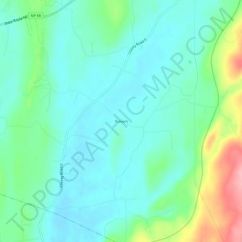
Name: Pulvers topographic map, elevation, terrain.
Average elevation: 111 m
Minimum elevation: 78 m
Maximum elevation: 212 m
Other topographic maps
Click on a map to view its topography, its elevation and its terrain.
Arnolds Mill
United States > New York > Columbia County > Town of Ghent
Arnolds Mill, Town of Ghent, Columbia County, New York, 12037, United States
Average elevation: 178 m
West Ghent
United States > New York > Columbia County > Town of Ghent
West Ghent, Town of Ghent, Columbia County, New York, 12174, United States
Average elevation: 72 m
Omi
United States > New York > Columbia County > Town of Ghent
Omi, Town of Ghent, Columbia County, New York, 12075, United States
Average elevation: 93 m
Buckleyville
United States > New York > Columbia County > Town of Ghent
Buckleyville, Town of Ghent, Columbia County, New York, 12037, United States
Average elevation: 157 m