
Thank you for supporting this site ❤️
Make a donation
Make a donation
Fervaques topographic map
Click on the map to display elevation.
Thank you for supporting this site ❤️
Make a donation
Make a donation
About this map
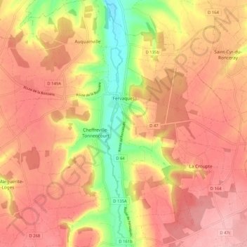
Name: Fervaques topographic map, elevation, terrain.
Average elevation: 157 m
Minimum elevation: 68 m
Maximum elevation: 208 m
Thank you for supporting this site ❤️
Make a donation
Make a donation
Other topographic maps
Click on a map to view its topography, its elevation and its terrain.
Quartier de l'Église
France > Normandie > Calvados > Livarot-Pays-d'Auge > Le Mesnil-Bacley
Average elevation: 124 m
Cour des Sourciers
France > Normandie > Calvados > Livarot-Pays-d'Auge > Fervaques
Average elevation: 143 m
Thank you for supporting this site ❤️
Make a donation
Make a donation
Manoir de Lortier
France > Normandie > Calvados > Livarot-Pays-d'Auge > Manoir de Lortier
Average elevation: 133 m
La Vatterie
France > Normandie > Calvados > Livarot-Pays-d'Auge > Préaux-Saint-Sébastien
Average elevation: 196 m