
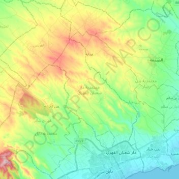
Dar Chaabane El Fehri topographic map
Interactive map
Click on the map to display elevation.
About this map
Name: Dar Chaabane El Fehri topographic map, elevation, terrain.
Location: Dar Chaabane El Fehri, Nabeul, Tunisie (36.44425 10.62216 36.59187 10.77093)
Average elevation: 110 m
Minimum elevation: -1 m
Maximum elevation: 322 m
Other topographic maps
Click on a map to view its topography, its elevation and its terrain.
Menzel Bou Zelfa
Tunisie > Nabeul > Menzel Bou Zelfa
Menzel Bou Zelfa, Menzel Bouzelfa Sud, Menzel Bouzelfa, Nabeul, 8010, Tunisie
Average elevation: 47 m
Bir Challouf
Tunisie > Nabeul > Bir Challouf
Bir Challouf, Neapolis, Nabeul, 8000, Tunisie
Average elevation: 15 m