
Make a donation
Passau topographic map
Click on the map to display elevation.
Make a donation
Passau
On 2 June 2013, the old town suffered from severe flooding as a result of several days of rain and its location at the confluence of three rivers. Peak elevations of floods as early as 1501 are displayed on a wall at the Old City Hall. Flood water reaches the base of that wall on average once every 5 years.
Make a donation
About this map
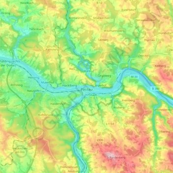
Name: Passau topographic map, elevation, terrain.
Location: Passau, Bavaria, Germany (48.54045 13.30234 48.61342 13.51439)
Average elevation: 401 m
Minimum elevation: 282 m
Maximum elevation: 585 m
Make a donation
Other topographic maps
Click on a map to view its topography, its elevation and its terrain.
Neuschwanstein Castle
Germany > Bavaria > Landkreis Ostallgäu > Hohenschwangau
The municipality of Schwangau lies at an elevation of 800 m (2,620 ft) at the southwest border of the German state of Bavaria. Its surroundings are characterised by the transition between the Alpine foothills in the south (toward the nearby Austrian border) and a hilly landscape in the north that appears flat…
Average elevation: 982 m
Make a donation
Make a donation
Ziegelhütte
Germany > Bavaria > Landkreis Wunsiedel im Fichtelgebirge > Marktredwitz
Average elevation: 563 m
Make a donation
Make a donation
Schönbühl
Germany > Bavaria > Landkreis Dingolfing-Landau > Dingolfing > Kronwieden
Average elevation: 375 m