
Thank you for supporting this site ❤️
Make a donation
Make a donation
Northfield topographic map
Click on the map to display elevation.
Thank you for supporting this site ❤️
Make a donation
Make a donation
About this map
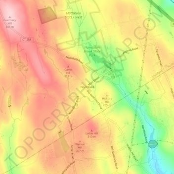
Name: Northfield topographic map, elevation, terrain.
Average elevation: 259 m
Minimum elevation: 131 m
Maximum elevation: 344 m
Thank you for supporting this site ❤️
Make a donation
Make a donation
Other topographic maps
Click on a map to view its topography, its elevation and its terrain.
Litchfield (borough)
United States > Connecticut > Northwest Hills Planning Region > Litchfield
Average elevation: 307 m