
Nimbarga topographic map
Interactive map
Click on the map to display elevation.
About this map
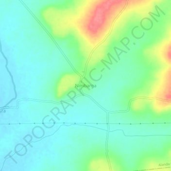
Name: Nimbarga topographic map, elevation, terrain.
Location: Nimbarga, Alanda taluku, Kalaburagi District, Karnataka, India (17.36608 76.56534 17.40608 76.60534)
Average elevation: 442 m
Minimum elevation: 420 m
Maximum elevation: 495 m
Other topographic maps
Click on a map to view its topography, its elevation and its terrain.
Kadaganchi
India > Karnataka > Alanda taluku
Kadaganchi, Alanda taluku, Kalaburagi District, Karnataka, 585311, India
Average elevation: 528 m
Honalli
India > Karnataka > Alanda taluku
Honalli, Alanda taluku, Kalaburagi District, Karnataka, India
Average elevation: 540 m