
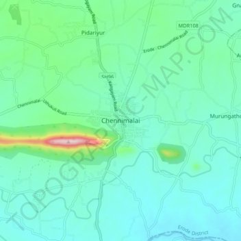
Chennimalai topographic map
Interactive map
Click on the map to display elevation.
About this map
Name: Chennimalai topographic map, elevation, terrain.
Average elevation: 267 m
Minimum elevation: 212 m
Maximum elevation: 513 m
Other topographic maps
Click on a map to view its topography, its elevation and its terrain.
Orathupalayam Dam
India > Tamil Nadu > Perundurai
Orathupalayam Dam, Perundurai, Erode District, Tamil Nadu, India
Average elevation: 246 m
Saralai
India > Tamil Nadu > Perundurai
Saralai, Perundurai, Erode District, Tamil Nadu, 638057, India
Average elevation: 301 m
Thingalur
India > Tamil Nadu > Perundurai
Thingalur, Perundurai, Erode District, Tamil Nadu, 638055, India
Average elevation: 288 m