
Thank you for supporting this site ❤️
Make a donation
Make a donation
Schleiz topographic map
Click on the map to display elevation.
Thank you for supporting this site ❤️
Make a donation
Make a donation
About this map
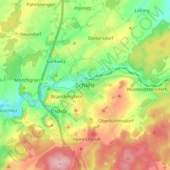
Name: Schleiz topographic map, elevation, terrain.
Location: Schleiz, Saale-Orla-Kreis, Thuringia, 07907, Germany (50.53744 11.76891 50.61744 11.84891)
Average elevation: 479 m
Minimum elevation: 397 m
Maximum elevation: 593 m
Thank you for supporting this site ❤️
Make a donation
Make a donation
Other topographic maps
Click on a map to view its topography, its elevation and its terrain.
Thank you for supporting this site ❤️
Make a donation
Make a donation
Thank you for supporting this site ❤️
Make a donation
Make a donation
Thank you for supporting this site ❤️
Make a donation
Make a donation