Geolocate

金寨县 topographic map

Interactive map

Click on the map to display elevation.

About this map

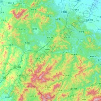
Name: 金寨县 topographic map, elevation, terrain.

Location: 金寨县, 六安市, 安徽省, 中国 (31.10538 115.36585 31.81123 116.19401)

Average elevation: 407 m

Minimum elevation: 38 m

Maximum elevation: 1,720 m

金寨县地势自西南向东北方向阶梯状下降。大别山由西南向东北贯穿全境,群山起伏,河流纵横,千米以上山峰有116座,主峰天堂寨海拔1729.1米,最低处是白塔畈乡的灌口集,海拔59.5米。

Wikipedia (CC-BY-SA 3.0)

Other topographic maps

Click on a map to view its topography, its elevation and its terrain.

霍山县

中国 > 安徽省 > 六安市

霍山县, 六安市, 安徽省, 中国

Average elevation: 429 m

汤家汇镇

中国 > 安徽省 > 六安市

汤家汇镇, 六安市, 安徽省, 中国

Average elevation: 308 m

叶集区

中国 > 安徽省 > 六安市

叶集区, 六安市, 安徽省, 中国

Average elevation: 84 m

大河沿

中国 > 安徽省 > 六安市

大河沿, 六安市, 安徽省, 中国

Average elevation: 120 m

裕安区

中国 > 安徽省 > 六安市

裕安区, 六安市, 安徽省, 中国

Average elevation: 63 m

霍邱县

中国 > 安徽省 > 六安市

霍邱县, 六安市, 安徽省, 中国

Average elevation: 34 m

舒城县

中国 > 安徽省 > 六安市

舒城县, 六安市, 安徽省, 231300, 中国

Average elevation: 172 m

三湾

中国 > 安徽省 > 六安市

三湾, 六安市, 安徽省, 中国

Average elevation: 76 m

兴丰

中国 > 安徽省 > 六安市 > 兴丰

兴丰, 六安市, 安徽省, 中国

Average elevation: 12 m