
Make a donation
Ennal topographic map
Click on the map to display elevation.
Make a donation
About this map
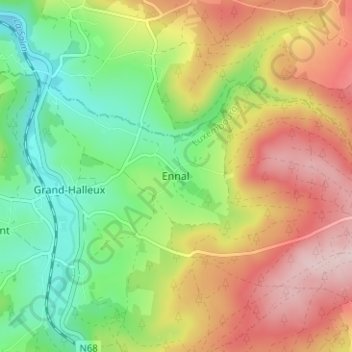
Name: Ennal topographic map, elevation, terrain.
Location: Ennal, Vielsalm, Bastogne, Luxembourg, Wallonia, 6698, Belgium (50.30780 5.90622 50.34780 5.94622)
Average elevation: 418 m
Minimum elevation: 287 m
Maximum elevation: 578 m
Make a donation
Other topographic maps
Click on a map to view its topography, its elevation and its terrain.
Bastogne
Belgium > Luxembourg > Bastogne
The municipality consists of the following districts: Bastogne, Longvilly, Noville, Villers-la-Bonne-Eau, and Wardin. The town is situated on a ridge in the Ardennes at an elevation of 510 metres (1,670 ft).
Average elevation: 464 m
Make a donation
Make a donation
Bastogne
Belgium > Luxembourg > Bastogne
The municipality consists of the following districts: Bastogne, Longvilly, Noville, Villers-la-Bonne-Eau, and Wardin. The town is situated on a ridge in the Ardennes at an elevation of 510 metres (1,670 ft).
Average elevation: 464 m
Make a donation
Bastogne
Belgium > Luxembourg > Bastogne
The municipality consists of the following districts: Bastogne, Longvilly, Noville, Villers-la-Bonne-Eau, and Wardin. The town is situated on a ridge in the Ardennes at an elevation of 510 metres (1,670 ft).
Average elevation: 464 m
Make a donation