
Make a donation
Kahramankazan topographic map
Click on the map to display elevation.
Make a donation
Kahramankazan
Kahramankazan (previously named Kazan) is a town and district of the Ankara Province in the Central Anatolia region of Turkey, standing on the plain of Akıncı to the north west of the city of Ankara. According to 2010 census, population of the district is 39,537 of which 37,718 live in the town of Kahramankazan. The district covers an area of 408 km2 (158 sq mi), and the average elevation is 890 m (2,920 ft).
Make a donation
About this map
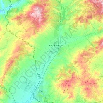
Name: Kahramankazan topographic map, elevation, terrain.
Location: Kahramankazan, Ankara, Central Anatolia Region, 06980, Turkey (40.02499 32.51208 40.33806 32.87435)
Average elevation: 1,091 m
Minimum elevation: 798 m
Maximum elevation: 1,718 m
Make a donation
Other topographic maps
Click on a map to view its topography, its elevation and its terrain.
Make a donation
Make a donation
Make a donation
Gaziantep
The plan introduced several important changes to the city's transportation network. One of the most important was the addition of a rail line to connect Gaziantep to the national rail system. Up to now, Turkish railway construction had ignored Gaziantep (partly because of its mountainous surroundings); a…
Average elevation: 880 m
Make a donation
Make a donation
Make a donation
Make a donation
Make a donation
Make a donation
Make a donation
Make a donation
Make a donation
Make a donation
Make a donation
Make a donation
Make a donation
Make a donation
Make a donation
Make a donation
Make a donation
Değirmendere
Çorum (Turkish pronunciation: [ˈtʃoɾum]) (Medieval Greek: Ευχάνεια, romanized: Euchaneia) is a northern Anatolian city that is the capital of the Çorum Province of Turkey. Çorum is located inland in the central Black Sea Region of Turkey, and is approximately 244 km (152 mi) from Ankara and 608…
Average elevation: 1,263 m
Make a donation
Make a donation
Hacıbektaş
Turkey > Hacıbektaş > Hacıbektaş
Hacıbektaş, formerly Karahöyük, is a town and district of Nevşehir Province in the Central Anatolia region of Turkey. According to 2000 census, population of the district is 11,929 of which 5,169 live in the town of Hacıbektaş. Located in Cappadocia, the district covers an area of 697 km2 (269 sq mi),…
Average elevation: 1,269 m
Make a donation
Make a donation
Make a donation