
Thank you for supporting this site ❤️
Make a donation
Make a donation
Freystadt topographic map
Click on the map to display elevation.
Thank you for supporting this site ❤️
Make a donation
Make a donation
About this map
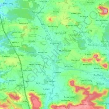
Name: Freystadt topographic map, elevation, terrain.
Average elevation: 436 m
Minimum elevation: 381 m
Maximum elevation: 591 m
Thank you for supporting this site ❤️
Make a donation
Make a donation
Other topographic maps
Click on a map to view its topography, its elevation and its terrain.
St. Wolfgang
Germany > Bavaria > Landkreis Neumarkt in der Oberpfalz > Dantersdorf
Average elevation: 548 m
Großbissendorf
Germany > Bavaria > Landkreis Neumarkt in der Oberpfalz > Großbissendorf
Average elevation: 492 m