
黑龙江省 topographic map
Interactive map
Click on the map to display elevation.
About this map
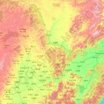
Name: 黑龙江省 topographic map, elevation, terrain.
Location: 黑龙江省, 中国 (43.42323 121.18411 53.56082 134.77546)
Average elevation: 417 m
Minimum elevation: 0 m
Maximum elevation: 2,176 m
黑龙江省地势复杂多样,大体为西北、北部、东南部高,东部和西南部低。主要由山地、台地、平原和水面构成,大体可概括为“五山一水一草三分田”。本省地形可分五区:
Other topographic maps
Click on a map to view its topography, its elevation and its terrain.