
Thank you for supporting this site ❤️
Make a donation
Make a donation
Pocitos topographic map
Click on the map to display elevation.
Thank you for supporting this site ❤️
Make a donation
Make a donation
About this map
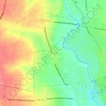
Name: Pocitos topographic map, elevation, terrain.
Average elevation: 1,871 m
Minimum elevation: 1,836 m
Maximum elevation: 1,909 m
Thank you for supporting this site ❤️
Make a donation
Make a donation
Other topographic maps
Click on a map to view its topography, its elevation and its terrain.
Parque Tres Centurias
México > Aguascalientes > Municipio de Aguascalientes > Aguascalientes
Average elevation: 1,884 m
El Sabinal
México > Aguascalientes > Municipio de Aguascalientes > El Salto de los Salado
Average elevation: 1,825 m
Parque Rodolfo Landeros
México > Aguascalientes > Municipio de Aguascalientes > Aguascalientes
Average elevation: 1,947 m
Parque México La Presa
México > Aguascalientes > Municipio de Aguascalientes > Aguascalientes
Average elevation: 1,932 m
Thank you for supporting this site ❤️
Make a donation
Make a donation
Parque Mexico
México > Aguascalientes > Municipio de Aguascalientes > Aguascalientes
Average elevation: 1,928 m