
Moulin Kergaer topographic map
Interactive map
Click on the map to display elevation.
About this map
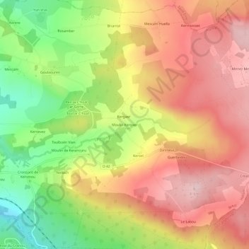
Name: Moulin Kergaer topographic map, elevation, terrain.
Average elevation: 214 m
Minimum elevation: 76 m
Maximum elevation: 321 m
Other topographic maps
Click on a map to view its topography, its elevation and its terrain.
Roc'h Glujau
France > Bretagne > Finistère > Hanvec > Menez Meur
Roc'h Glujau, Accès Privé, Domaine de Ménez Meur, Menez Meur, Hanvec, Brest, Finistère, Bretagne, France métropolitaine, 29460, France
Average elevation: 267 m
Ty Kermarec
France > Bretagne > Finistère > Hanvec
Ty Kermarec, Hanvec, Brest, Finistère, Bretagne, France métropolitaine, 29460, France
Average elevation: 76 m