
Make a donation
Hohenwart topographic map
Click on the map to display elevation.
Make a donation
Hohenwart
2018 gab es nach der amtlichen Statistik in der Gemeinde 2054 sozialversicherungspflichtige Arbeitsplätze. Von der Wohnbevölkerung standen 1745 Personen in einer versicherungspflichtigen Tätigkeit. Die Zahl der Einpendler war um 209 Personen höher als die der Auspendler. Von den Einwohnern waren 27 arbeitslos. Die 95 landwirtschaftlichen Betriebe (Stand 2016) bewirtschafteten insgesamt 2879 Hektar Nutzfläche.
Make a donation
About this map
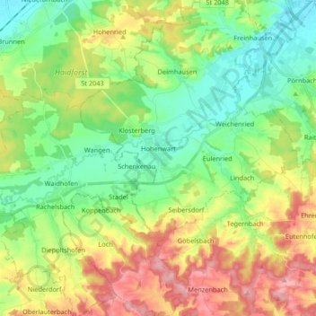
Name: Hohenwart topographic map, elevation, terrain.
Average elevation: 435 m
Minimum elevation: 379 m
Maximum elevation: 527 m
Make a donation
Other topographic maps
Click on a map to view its topography, its elevation and its terrain.
Straßhöfe
Deutschland > Bayern > Landkreis Pfaffenhofen an der Ilm > Rohrbach an der Ilm
Average elevation: 426 m
Holzleiten
Deutschland > Bayern > Landkreis Pfaffenhofen an der Ilm > Geisenfeld
Average elevation: 386 m
Make a donation
Gotteshofen
Deutschland > Bayern > Landkreis Pfaffenhofen an der Ilm > Reichertshofen > Reichertshofen
Average elevation: 388 m
Untermettenbach
Deutschland > Bayern > Landkreis Pfaffenhofen an der Ilm > Geisenfeld > Untermettenbach
Average elevation: 420 m
Make a donation
Fahlenbach
Deutschland > Bayern > Landkreis Pfaffenhofen an der Ilm > Rohrbach
Average elevation: 412 m
Weingarten
Deutschland > Bayern > Landkreis Pfaffenhofen an der Ilm > Pfaffenhofen an der Ilm > Haimpertshofen
Average elevation: 451 m
Fürholzen
Deutschland > Bayern > Landkreis Pfaffenhofen an der Ilm > Rohrbach
Average elevation: 432 m
Make a donation
Haimpertshofen
Deutschland > Bayern > Landkreis Pfaffenhofen an der Ilm > Pfaffenhofen an der Ilm
Average elevation: 448 m
Make a donation
Eichelberg
Deutschland > Bayern > Landkreis Pfaffenhofen an der Ilm > Geisenfeld
Average elevation: 402 m
Make a donation
Make a donation
Engelbrechtsmünster
Deutschland > Bayern > Landkreis Pfaffenhofen an der Ilm > Geisenfeld
Average elevation: 383 m
Siebeneichmühle
Deutschland > Bayern > Landkreis Pfaffenhofen an der Ilm > Pfaffenhofen an der Ilm > Affalterbach
Average elevation: 440 m
Make a donation
Wasenstatt
Deutschland > Bayern > Landkreis Pfaffenhofen an der Ilm > Pfaffenhofen an der Ilm > Göbelsbach
Average elevation: 451 m
Gambach
Deutschland > Bayern > Landkreis Pfaffenhofen an der Ilm > Rohrbach an der Ilm
Average elevation: 440 m
Make a donation
Hög
Deutschland > Bayern > Landkreis Pfaffenhofen an der Ilm > Reichertshofen
Average elevation: 410 m
Pleiling
Deutschland > Bayern > Landkreis Pfaffenhofen an der Ilm > Vohburg an der Donau > Pleiling
Average elevation: 400 m
Make a donation
Affalterbach
Deutschland > Bayern > Landkreis Pfaffenhofen an der Ilm > Pfaffenhofen an der Ilm > Affalterbach
Average elevation: 439 m
Tegernbach
Deutschland > Bayern > Landkreis Pfaffenhofen an der Ilm > Pfaffenhofen an der Ilm > Tegernbach
Average elevation: 458 m
Siebeneich
Deutschland > Bayern > Landkreis Pfaffenhofen an der Ilm > Kohlstatt > Siebeneich
Average elevation: 497 m
Jebertshausen
Deutschland > Bayern > Landkreis Pfaffenhofen an der Ilm > Wolnzach > Jebertshausen
Average elevation: 449 m
Make a donation
Hagberg
Deutschland > Bayern > Landkreis Pfaffenhofen an der Ilm > Hettenshausen
Average elevation: 453 m
Egg
Deutschland > Bayern > Landkreis Pfaffenhofen an der Ilm > Wolnzach > Egg
Average elevation: 482 m
Sankt Kastl
Deutschland > Bayern > Landkreis Pfaffenhofen an der Ilm > Stöffel > Sankt Kastl
Average elevation: 432 m
Knodorf
Deutschland > Bayern > Landkreis Pfaffenhofen an der Ilm > Vohburg an der Donau
Average elevation: 360 m
Make a donation
Oberhartheim
Deutschland > Bayern > Landkreis Pfaffenhofen an der Ilm > Vohburg an der Donau
Average elevation: 394 m