
Thank you for supporting this site ❤️
Make a donation
Make a donation
Black Mountain topographic map
Click on the map to display elevation.
Thank you for supporting this site ❤️
Make a donation
Make a donation
About this map
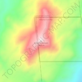
Name: Black Mountain topographic map, elevation, terrain.
Location: Black Mountain, Albany County, Wyoming, United States (42.31131 -105.37642 42.31141 -105.37632)
Average elevation: 2,172 m
Minimum elevation: 1,922 m
Maximum elevation: 2,434 m
Thank you for supporting this site ❤️
Make a donation
Make a donation
Other topographic maps
Click on a map to view its topography, its elevation and its terrain.
Laramie
United States > Wyoming > Albany County
Laramie (/ˈlærəmi/) is a city in and the county seat of Albany County, Wyoming, United States known for its high elevation at 7,200 feet, railroad history, and as the higher-education center for the state of Wyoming. The population was estimated 31,407 in 2020, making it the 4th most populous city in…
Average elevation: 2,219 m