
Thank you for supporting this site ❤️
Make a donation
Make a donation
Baden topographic map
Click on the map to display elevation.
Thank you for supporting this site ❤️
Make a donation
Make a donation
About this map
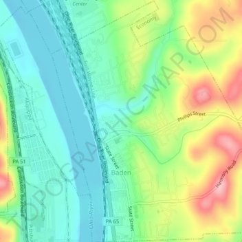
Name: Baden topographic map, elevation, terrain.
Location: Baden, Beaver County, Pennsylvania, United States (40.62625 -80.23981 40.65675 -80.20709)
Average elevation: 258 m
Minimum elevation: 206 m
Maximum elevation: 358 m
Thank you for supporting this site ❤️
Make a donation
Make a donation
Other topographic maps
Click on a map to view its topography, its elevation and its terrain.
North Rochester
United States > Pennsylvania > Beaver County > Rochester Township
Average elevation: 283 m
Ambridge Heights
United States > Pennsylvania > Beaver County > Harmony Township
Average elevation: 278 m
Rowtown
United States > Pennsylvania > Beaver County > South Beaver Township > Rowtown
Average elevation: 322 m
Thank you for supporting this site ❤️
Make a donation
Make a donation