
Make a donation
Bavaria topographic map
Click on the map to display elevation.
Make a donation
About this map
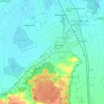
Name: Bavaria topographic map, elevation, terrain.
Location: Bavaria, 86690, Germany (48.61898 10.73666 48.68715 10.84792)
Average elevation: 413 m
Minimum elevation: 400 m
Maximum elevation: 460 m
Make a donation
Other topographic maps
Click on a map to view its topography, its elevation and its terrain.
Funtensee
Germany > Bavaria > Landkreis Berchtesgadener Land > Schönau am Königssee
The lake lies at an elevation of 1601 m and has a surface area is 3.5 ha. Its outflow toward the Schrainbach is subterranean at a location called Teufelsmühle. On its shore is the Kärlinger Haus mountain hut which is open for the summer season; in addition, there is a winter room available. The valley is…
Average elevation: 1,813 m
Kritzower See
Germany > Mecklenburg-Vorpommern > Ludwigslust-Parchim > Kritzow
Kritzower See is a lake in the Ludwigslust-Parchim district in Mecklenburg-Vorpommern, Germany. At an elevation of 60 m, its surface area is 0.63 km².
Average elevation: 66 m
Make a donation
Make a donation