
Thank you for supporting this site ❤️
Make a donation
Make a donation
Eppegem topographic map
Click on the map to display elevation.
Thank you for supporting this site ❤️
Make a donation
Make a donation
About this map
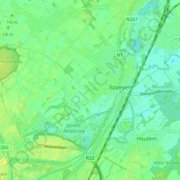
Name: Eppegem topographic map, elevation, terrain.
Location: Eppegem, Zemst, Hal-Vilvorde, Brabant flamand, Flandre, Belgique (50.94653 4.41253 50.97485 4.47753)
Average elevation: 11 m
Minimum elevation: 3 m
Maximum elevation: 19 m
Thank you for supporting this site ❤️
Make a donation
Make a donation
Other topographic maps
Click on a map to view its topography, its elevation and its terrain.