
Altdörnfeld topographic map
Interactive map
Click on the map to display elevation.
About this map
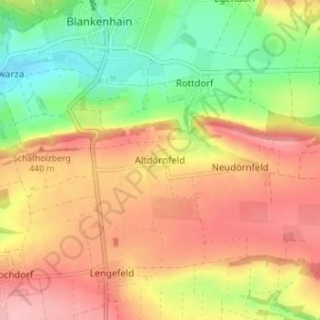
Name: Altdörnfeld topographic map, elevation, terrain.
Average elevation: 403 m
Minimum elevation: 335 m
Maximum elevation: 463 m
Other topographic maps
Click on a map to view its topography, its elevation and its terrain.
Keßlar
Deutschland > Thüringen > Landkreis Weimarer Land > Blankenhain > Keßlar
Keßlar, Blankenhain, Landkreis Weimarer Land, Thüringen, Deutschland
Average elevation: 413 m