
Thank you for supporting this site ❤️
Make a donation
Make a donation
Hagen topographic map
Click on the map to display elevation.
Thank you for supporting this site ❤️
Make a donation
Make a donation
About this map
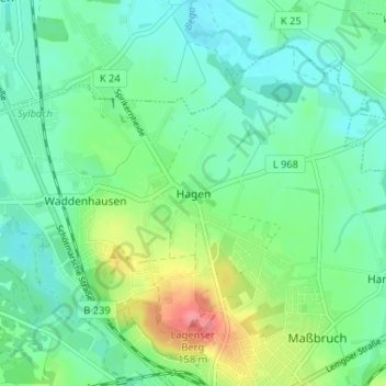
Name: Hagen topographic map, elevation, terrain.
Average elevation: 101 m
Minimum elevation: 78 m
Maximum elevation: 161 m
Thank you for supporting this site ❤️
Make a donation
Make a donation
Other topographic maps
Click on a map to view its topography, its elevation and its terrain.
Waddenhausen
Deutschland > Nordrhein-Westfalen > Kreis Lippe > Lage
Der „Reinholdi-Markt“ wird seit mehr als 90 Jahren dort abgehalten. Es begann mit einem „Luna-Park“, der vom Samstag, dem 13. Oktober 1928, bis Montag, dem 15. Oktober 1928, am Siekkrug von dem Wirt Reinhold Radtke veranstaltet wurde, um die Auslastung seiner Wirtschaft zu erhöhen.
Average elevation: 102 m
Thank you for supporting this site ❤️
Make a donation
Make a donation