
Thank you for supporting this site ❤️
Make a donation
Make a donation
La Cage topographic map
Click on the map to display elevation.
Thank you for supporting this site ❤️
Make a donation
Make a donation
About this map
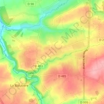
Name: La Cage topographic map, elevation, terrain.
Average elevation: 130 m
Minimum elevation: 71 m
Maximum elevation: 179 m
Thank you for supporting this site ❤️
Make a donation
Make a donation
Other topographic maps
Click on a map to view its topography, its elevation and its terrain.
50410
France > Normandie > Manche > Percy-en-Normandie > Percy > Les Hauts Vents
Average elevation: 139 m