
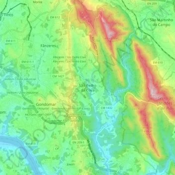
São Pedro da Cova topographic map
Interactive map
Click on the map to display elevation.
About this map
Name: São Pedro da Cova topographic map, elevation, terrain.
Location: São Pedro da Cova, Gondomar, Porto, 4510-398, Portugal (41.10737 -8.54742 41.18737 -8.46742)
Average elevation: 123 m
Minimum elevation: 1 m
Maximum elevation: 380 m
Other topographic maps
Click on a map to view its topography, its elevation and its terrain.
Vila Verde
Vila Verde, Gondomar (São Cosme), Valbom e Jovim, Gondomar, Porto, 4300-378, Portugal
Average elevation: 65 m