
Thank you for supporting this site ❤️
Make a donation
Make a donation
Pont-de-Crau topographic map
Click on the map to display elevation.
Thank you for supporting this site ❤️
Make a donation
Make a donation
About this map
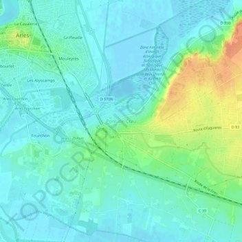
Name: Pont-de-Crau topographic map, elevation, terrain.
Average elevation: 11 m
Minimum elevation: -3 m
Maximum elevation: 42 m
Thank you for supporting this site ❤️
Make a donation
Make a donation
Other topographic maps
Click on a map to view its topography, its elevation and its terrain.
Étang de la Galére
France > Provence-Alpes-Côte d'Azur > Bouches-du-Rhône > Arles
Average elevation: -1 m
Raphèle-lès-Arles
France > Provence-Alpes-Côte d'Azur > Bouches-du-Rhône > Arles
Average elevation: 5 m
Marais de Meyranne
France > Provence-Alpes-Côte d'Azur > Bouches-du-Rhône > Arles
Average elevation: 2 m
Canal de Fumemorte
France > Provence-Alpes-Côte d'Azur > Bouches-du-Rhône > Arles
Average elevation: 0 m
Thank you for supporting this site ❤️
Make a donation
Make a donation