
Mattersburg topographic map
Interactive map
Click on the map to display elevation.
About this map
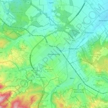
Name: Mattersburg topographic map, elevation, terrain.
Location: Mattersburg, Bezirk Mattersburg, Burgenland, 7210, Österreich (47.69684 16.35805 47.77684 16.43805)
Average elevation: 284 m
Minimum elevation: 195 m
Maximum elevation: 534 m
Vor Christi Geburt war das Gebiet Teil des keltischen Königreiches Noricum und gehörte zur Umgebung der keltischen Höhensiedlung Burg auf dem Schwarzenbacher Burgberg.