
Unterelchingen topographic map
Interactive map
Click on the map to display elevation.
About this map
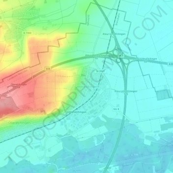
Name: Unterelchingen topographic map, elevation, terrain.
Average elevation: 476 m
Minimum elevation: 447 m
Maximum elevation: 556 m
Other topographic maps
Click on a map to view its topography, its elevation and its terrain.
89275
Deutschland > Bayern > Landkreis Neu-Ulm > Elchingen > Oberelchingen
89275, Oberelchingen, Elchingen, Landkreis Neu-Ulm, Bayern, Deutschland
Average elevation: 499 m
Thalfingen
Deutschland > Bayern > Landkreis Neu-Ulm > Elchingen
Thalfingen, Elchingen, Landkreis Neu-Ulm, Bayern, 89275, Deutschland
Average elevation: 507 m