
Crooked Island topographic map
Interactive map
Click on the map to display elevation.
About this map
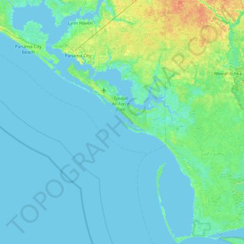
Name: Crooked Island topographic map, elevation, terrain.
Location: Crooked Island, Bay County, Florida, USA (29.66437 -85.84103 30.30437 -85.20103)
Average elevation: 4 m
Minimum elevation: -5 m
Maximum elevation: 31 m
Other topographic maps
Click on a map to view its topography, its elevation and its terrain.
The Villages
USA > Florida > The Villages
The Villages, Lake County, Florida, USA
Average elevation: 27 m
Yeet Pond
USA > Florida > Palm Coast
Yeet Pond, South Coopers Hawk Way, Palm Coast, Flagler County, Florida, USA
Average elevation: 7 m
Miami Beach
USA > Florida > Miami Beach
Miami Beach, Miami-Dade County, Florida, USA
Average elevation: 3 m
Dry Tortugas National Park
Dry Tortugas National Park, Monroe County, Florida, USA
Average elevation: 0 m
St. Augustine
USA > Florida > St. Augustine
St. Augustine, St. Johns County, Florida, 32084, USA
Average elevation: 5 m
Deerfield Beach
USA > Florida > Deerfield Beach
Deerfield Beach, Broward County, Florida, USA
Average elevation: 5 m
Altamonte Springs
USA > Florida > Altamonte Springs
Altamonte Springs, Seminole County, Florida, USA
Average elevation: 26 m
Dawson Island
USA > Florida > Jacksonville
Dawson Island, Jacksonville, Duval County, Florida, USA
Average elevation: 2 m