
Saint-Remy-l'Abbaye topographic map
Interactive map
Click on the map to display elevation.
About this map
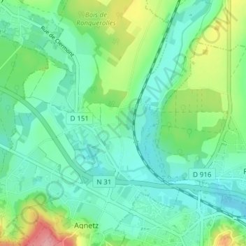
Name: Saint-Remy-l'Abbaye topographic map, elevation, terrain.
Average elevation: 76 m
Minimum elevation: 46 m
Maximum elevation: 156 m
Other topographic maps
Click on a map to view its topography, its elevation and its terrain.
Ramécourt
France > Hauts-de-France > Oise > Agnetz
Ramécourt, Agnetz, Clermont, Oise, Hauts-de-France, France métropolitaine, 60600, France
Average elevation: 85 m
Boulincourt
France > Hauts-de-France > Oise > Agnetz
Boulincourt, Agnetz, Clermont, Oise, Hauts-de-France, France métropolitaine, 60600, France
Average elevation: 108 m