
Gunther Park topographic map
Interactive map
Click on the map to display elevation.
About this map
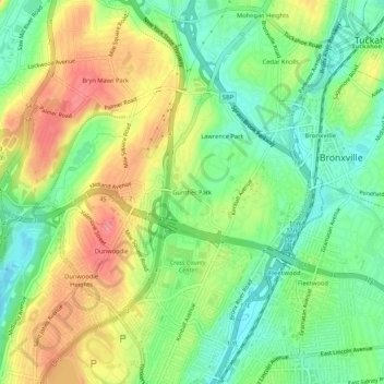
Name: Gunther Park topographic map, elevation, terrain.
Average elevation: 56 m
Minimum elevation: 17 m
Maximum elevation: 106 m
Other topographic maps
Click on a map to view its topography, its elevation and its terrain.
Cecil Park
United States > New York > Westchester County > City of Yonkers
Cecil Park, City of Yonkers, Westchester County, New York, 10707, United States
Average elevation: 70 m
Park Hill
United States > New York > Westchester County > City of Yonkers
Park Hill, City of Yonkers, Westchester County, New York, 10705, United States
Average elevation: 43 m
Colonial Heights
United States > New York > Westchester County > City of Yonkers
Colonial Heights, City of Yonkers, Westchester County, New York, 10710, United States
Average elevation: 60 m
Grey Oaks
United States > New York > Westchester County > City of Yonkers
Grey Oaks, City of Yonkers, Westchester County, New York, 10703, United States
Average elevation: 60 m
Lowerre
United States > New York > Westchester County > City of Yonkers
Lowerre, City of Yonkers, Westchester County, New York, 10705, United States
Average elevation: 34 m
Crestwood Gardens
United States > New York > Westchester County > City of Yonkers
Crestwood Gardens, City of Yonkers, Westchester County, New York, 10707, United States
Average elevation: 65 m
Bronxville Heights
United States > New York > Westchester County > City of Yonkers
Bronxville Heights, City of Yonkers, Westchester County, New York, 10710, United States
Average elevation: 63 m
Nepperhan
United States > New York > Westchester County > City of Yonkers
Nepperhan, City of Yonkers, Westchester County, New York, 10703, United States
Average elevation: 64 m