
La Plana topographic map
Interactive map
Click on the map to display elevation.
About this map
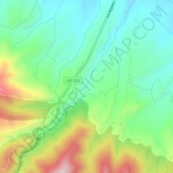
Name: La Plana topographic map, elevation, terrain.
Location: La Plana, Arnedo, La Rioja, 26587, España (42.16842 -2.10257 42.18842 -2.08257)
Average elevation: 735 m
Minimum elevation: 624 m
Maximum elevation: 955 m
Other topographic maps
Click on a map to view its topography, its elevation and its terrain.