
Macuiltépetl topographic map
Interactive map
Click on the map to display elevation.
About this map
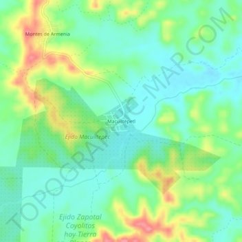
Name: Macuiltépetl topographic map, elevation, terrain.
Average elevation: 50 m
Minimum elevation: 18 m
Maximum elevation: 114 m
Other topographic maps
Click on a map to view its topography, its elevation and its terrain.
Terrenos del Lote "La Asunción"
Terrenos del Lote "La Asunción", Tuxpan, Veracruz, 92773, México
Average elevation: 29 m
Terrenos del Lote "Santiago de la Peña"
Terrenos del Lote "Santiago de la Peña", Tuxpan, Veracruz, México
Average elevation: 27 m
Alto Lucero
Alto Lucero, Terrenos del Lote "La Asunción", Tuxpan, Veracruz, 92860, México
Average elevation: 16 m