
Hite Point topographic map
Interactive map
Click on the map to display elevation.
About this map
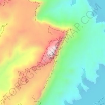
Name: Hite Point topographic map, elevation, terrain.
Location: Hite Point, Garfield County, Utah, United States (37.85967 -110.42973 37.85977 -110.42963)
Average elevation: 1,348 m
Minimum elevation: 1,109 m
Maximum elevation: 1,694 m
Other topographic maps
Click on a map to view its topography, its elevation and its terrain.
Cannonville
United States > Utah > Garfield County
Cannonville, Garfield County, Utah, 84718, United States
Average elevation: 1,894 m
Panguitch Lake
United States > Utah > Garfield County
Panguitch Lake, Garfield County, Utah, United States
Average elevation: 2,528 m
Bryce Canyon National Park
United States > Utah > Garfield County
Bryce Canyon National Park, Garfield County, Utah, United States
Average elevation: 2,259 m
Upper Calf Creek Fall
United States > Utah > Garfield County
Upper Calf Creek Fall, Garfield County, Utah, 84716, United States
Average elevation: 1,904 m
Piracy Point
United States > Utah > Garfield County
Piracy Point, Bryce Canyon Scenic Drive, Garfield County, Utah, United States
Average elevation: 2,551 m
Henderson Creek
United States > Utah > Garfield County
Henderson Creek, Garfield County, Utah, 84776, United States
Average elevation: 2,017 m
Antimony
United States > Utah > Garfield County
Antimony, Garfield County, Utah, 84712, United States
Average elevation: 2,061 m
Bryce Canyon
United States > Utah > Garfield County > Tropic
Bryce Canyon, Tropic, Garfield County, Utah, United States
Average elevation: 2,247 m
Escalante
United States > Utah > Garfield County
Escalante, Garfield County, Utah, 84726, United States
Average elevation: 1,781 m
Hatch
United States > Utah > Garfield County
Hatch, Garfield County, Utah, 84735, United States
Average elevation: 2,135 m
Bryce Canyon City
United States > Utah > Garfield County > Bryce Canyon City
Bryce Canyon City, Garfield County, Utah, 84764, United States
Average elevation: 2,337 m
Panguitch
United States > Utah > Garfield County > Panguitch
Panguitch, Garfield County, Utah, 87459, United States
Average elevation: 2,081 m
Andy Miller Flats
United States > Utah > Garfield County
Andy Miller Flats, Garfield County, Utah, United States
Average elevation: 1,604 m
Panguitch
United States > Utah > Garfield County
Panguitch, Garfield County, Utah, United States
Average elevation: 2,043 m
Capitol Reef National Park
United States > Utah > Garfield County
Capitol Reef National Park, Garfield County, Utah, United States
Average elevation: 1,963 m