Geolocate

Taizhou topographic map

Interactive map

Click on the map to display elevation.

About this map

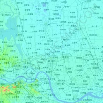
Name: Taizhou topographic map, elevation, terrain.

Location: Taizhou, Jiangsu, 225300, China (31.93468 119.63392 33.21324 120.55350)

Average elevation: 7 m

Minimum elevation: -2 m

Maximum elevation: 337 m

Other topographic maps

Click on a map to view its topography, its elevation and its terrain.

Yangzhou City

China > Jiangsu

Average elevation: 10 m

Suyu District

China > Jiangsu

Average elevation: 22 m

Yancheng City

China > Jiangsu

Average elevation: 3 m

Tinghu District

China > Jiangsu > Yancheng City

Average elevation: 2 m

Gaogang District

China > Jiangsu

Average elevation: 6 m

Lianyungang

China > Jiangsu

Average elevation: 17 m

Nanjing City

China > Jiangsu

There are mainly two types of soil in Nanjing: zonal soil and cultivated soil. The zonal soil is yellow-brown soil in the northern and central areas of Nanjing, and red soil in the southern part of the border with Anhui. The cultivated soil formed by human-made farming is mainly paddy soil, and there are some…

Average elevation: 29 m

Taihu Lake

China > Jiangsu

Average elevation: 14 m

海坝

China > Jiangsu > Nantong

Average elevation: 4 m

Purple Mountain

China > Jiangsu > Xuanwu District

A small mountain with an area of about 20 square kilometres (7.7 sq mi), the altitude of Purple Mountain at the top and foot of the mountain is about 448 metres (1,470 ft) and 20 metres (66 ft) respectively. The annual average rainfall is 1,000 millimetres (39 in) to 1,050 millimetres (41 in), and the average…

Average elevation: 73 m

Suzhou City

China > Jiangsu

Average elevation: 6 m

Zhenjiang

China > Jiangsu

Average elevation: 19 m