
Thank you for supporting this site ❤️
Make a donation
Make a donation
Marland topographic map
Click on the map to display elevation.
Thank you for supporting this site ❤️
Make a donation
Make a donation
About this map
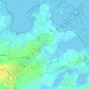
Name: Marland topographic map, elevation, terrain.
Average elevation: 4 m
Minimum elevation: -6 m
Maximum elevation: 29 m
Thank you for supporting this site ❤️
Make a donation
Make a donation
Other topographic maps
Click on a map to view its topography, its elevation and its terrain.
44117
France > Pays de la Loire > Loire-Atlantique > Saint-André-des-Eaux > Bilac
Average elevation: 9 m
44117
France > Pays de la Loire > Loire-Atlantique > Saint-André-des-Eaux > Bilac
Average elevation: 9 m