
Thank you for supporting this site ❤️
Make a donation
Make a donation
Liéry topographic map
Click on the map to display elevation.
Thank you for supporting this site ❤️
Make a donation
Make a donation
About this map
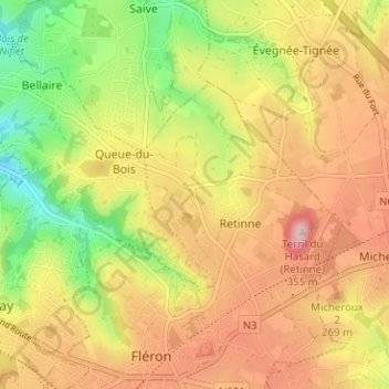
Name: Liéry topographic map, elevation, terrain.
Location: Liéry, Retinne, Fléron, Liège, Wallonie, 4620, Belgique (50.61339 5.67034 50.65339 5.71034)
Average elevation: 225 m
Minimum elevation: 119 m
Maximum elevation: 318 m
Thank you for supporting this site ❤️
Make a donation
Make a donation
Other topographic maps
Click on a map to view its topography, its elevation and its terrain.