
Nutten Hook State Tidal Wetland topographic map
Interactive map
Click on the map to display elevation.
About this map
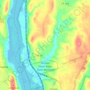
Name: Nutten Hook State Tidal Wetland topographic map, elevation, terrain.
Average elevation: 32 m
Minimum elevation: -5 m
Maximum elevation: 81 m
Other topographic maps
Click on a map to view its topography, its elevation and its terrain.
Stuyvesant Falls
United States > New York > Columbia County > Town of Stuyvesant
Stuyvesant Falls, Town of Stuyvesant, Columbia County, New York, 12174, United States
Average elevation: 58 m
Newton Hook
United States > New York > Columbia County > Town of Stuyvesant
Newton Hook, Town of Stuyvesant, Columbia County, New York, 12173, United States
Average elevation: 26 m
Poolsburg
United States > New York > Columbia County > Town of Stuyvesant
Poolsburg, Town of Stuyvesant, Columbia County, New York, 12124, United States
Average elevation: 39 m