
Bray topographic map
Interactive map
Click on the map to display elevation.
About this map
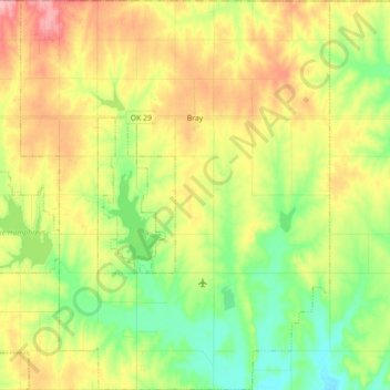
Name: Bray topographic map, elevation, terrain.
Location: Bray, Stephens County, Oklahoma, United States (34.53599 -97.89683 34.68162 -97.75622)
Average elevation: 368 m
Minimum elevation: 317 m
Maximum elevation: 433 m
Other topographic maps
Click on a map to view its topography, its elevation and its terrain.
Velma
United States > Oklahoma > Stephens County
Velma, Stephens County, Oklahoma, 73491, United States
Average elevation: 320 m
Comanche
United States > Oklahoma > Stephens County
Comanche, Stephens County, Oklahoma, 73529, United States
Average elevation: 315 m
Loco
United States > Oklahoma > Stephens County
Loco, Stephens County, Oklahoma, United States
Average elevation: 288 m
Countyline
United States > Oklahoma > Stephens County
Countyline, Stephens County, Oklahoma, 73425, United States
Average elevation: 310 m
Marlow
United States > Oklahoma > Stephens County
Marlow, Stephens County, Oklahoma, 73055, United States
Average elevation: 385 m
Duncan
United States > Oklahoma > Stephens County
Duncan, Stephens County, Oklahoma, 73533, United States
Average elevation: 350 m