
Thank you for supporting this site ❤️
Make a donation
Make a donation
Penhas Douradas topographic map
Click on the map to display elevation.
Thank you for supporting this site ❤️
Make a donation
Make a donation
About this map
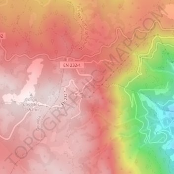
Name: Penhas Douradas topographic map, elevation, terrain.
Average elevation: 1,337 m
Minimum elevation: 855 m
Maximum elevation: 1,540 m
Thank you for supporting this site ❤️
Make a donation
Make a donation
Other topographic maps
Click on a map to view its topography, its elevation and its terrain.
Covão d'Ametade
O vidoeiro-branco (nome científico: Betula pendula), também chamado bétula-branca e vidoeiro-prateado é uma espécie de árvore caducifólia do género Betula. É uma árvore muito comum na generalidade da Europa, que se encontra desde a Noruega até à Sicília, embora nas região mais a sul só se…
Average elevation: 1,587 m