
Godarville topographic map
Interactive map
Click on the map to display elevation.
About this map
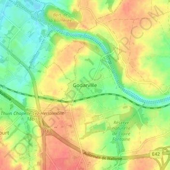
Name: Godarville topographic map, elevation, terrain.
Average elevation: 144 m
Minimum elevation: 116 m
Maximum elevation: 172 m
Other topographic maps
Click on a map to view its topography, its elevation and its terrain.
Piéton
Belgique > Hainaut > Charleroi > Chapelle-lez-Herlaimont
Piéton, Chapelle-lez-Herlaimont, Charleroi, Hainaut, Wallonie, 7160, Belgique
Average elevation: 165 m
Godarville
Belgique > Hainaut > Charleroi > Chapelle-lez-Herlaimont
Godarville, Chapelle-lez-Herlaimont, Charleroi, Hainaut, Wallonie, 7160, Belgique
Average elevation: 146 m
Chapelle-lez-Herlaimont
Belgique > Hainaut > Charleroi > Chapelle-lez-Herlaimont
Chapelle-lez-Herlaimont, Charleroi, Hainaut, Wallonie, 7160, Belgique
Average elevation: 148 m
Marie-la-Guerre
Belgique > Hainaut > Charleroi > Chapelle-lez-Herlaimont > Bascoup
Marie-la-Guerre, Bascoup, Chapelle-lez-Herlaimont, Charleroi, Hainaut, Wallonie, 7160, Belgique
Average elevation: 153 m
Le Douaire
Belgique > Hainaut > Charleroi > Chapelle-lez-Herlaimont > Bascoup
Le Douaire, Bascoup, Chapelle-lez-Herlaimont, Charleroi, Hainaut, Wallonie, 7160, Belgique
Average elevation: 159 m