
Gries topographic map
Interactive map
Click on the map to display elevation.
About this map
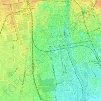
Name: Gries topographic map, elevation, terrain.
Location: Gries, Graz, Steiermark, Österreich (47.04035 15.40927 47.07135 15.44268)
Average elevation: 354 m
Minimum elevation: 338 m
Maximum elevation: 371 m
Other topographic maps
Click on a map to view its topography, its elevation and its terrain.
Haidegg
Österreich > Steiermark > Graz
Haidegg, Ries, Graz, Steiermark, 8047, Österreich
Average elevation: 446 m
Eisnitz
Österreich > Steiermark > Graz
Eisnitz, Mariatrost, Graz, Steiermark, 8044, Österreich
Average elevation: 501 m
Weinzödl
Österreich > Steiermark > Graz > Weinzödl
Weinzödl, Andritz, Graz, Steiermark, 8046, Österreich
Average elevation: 457 m
Eggenberg
Österreich > Steiermark > Graz
Eggenberg, Graz, Steiermark, Österreich
Average elevation: 429 m
Stadt Graz - Historisches Zentrum / Pufferzone (Südwest)
Österreich > Steiermark > Graz
Stadt Graz - Historisches Zentrum / Pufferzone (Südwest), Murvorstadt, Gries, Graz, Steiermark, 8020, Österreich
Average elevation: 360 m
Gösting
Österreich > Steiermark > Graz
Gösting, Graz, Steiermark, 8051, Österreich
Average elevation: 430 m
Innere Stadt
Österreich > Steiermark > Graz
Innere Stadt, Graz, Steiermark, Österreich
Average elevation: 364 m
Metahof-Schlössl
Österreich > Steiermark > Graz
Metahof-Schlössl, Rebengasse, Lend, Graz, Steiermark, 8020, Österreich
Average elevation: 363 m