
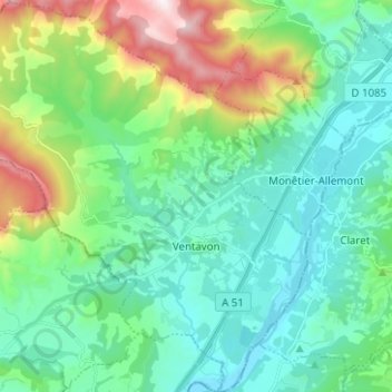
Ventavon topographic map
Interactive map
Click on the map to display elevation.
About this map
Name: Ventavon topographic map, elevation, terrain.
Average elevation: 761 m
Minimum elevation: 518 m
Maximum elevation: 1,528 m
Other topographic maps
Click on a map to view its topography, its elevation and its terrain.
Ailefroide
France > Provence-Alpes-Côte d'Azur > Hautes-Alpes > Vallouise-Pelvoux
Average elevation: 2,039 m
Lac du Sautet
France > Provence-Alpes-Côte d'Azur > Hautes-Alpes > Aspres-lès-Corps
Average elevation: 1,055 m
Pic Gaspard
France > Provence-Alpes-Côte d'Azur > Hautes-Alpes > Villar-d'Arêne
Average elevation: 3,145 m
Pramouton
France > Provence-Alpes-Côte d'Azur > Hautes-Alpes > Saint-André-d'Embrun
Average elevation: 2,085 m
Col du Lautaret
France > Provence-Alpes-Côte d'Azur > Hautes-Alpes > Le Monêtier-les-Bains
From the west, the climb starts at Les Clapier, near Le Bourg-d'Oisans, from where the climb is 34.2 km (21.3 mi) long, gaining 1,312 m (4,304 ft) in altitude, at an average gradient of 3.8%, with the steepest section being at 7.5% in the first kilometre.
Average elevation: 2,261 m
Les Gondoins
France > Provence-Alpes-Côte d'Azur > Hautes-Alpes > Les Borels
Average elevation: 1,737 m
Les Meyries
France > Provence-Alpes-Côte d'Azur > Hautes-Alpes > Freissinières
Average elevation: 1,477 m
Les Alpes
France > Provence-Alpes-Côte d'Azur > Hautes-Alpes > Saint-Marcelin
Average elevation: 1,073 m
Ctete de Praroussin
France > Provence-Alpes-Côte d'Azur > Hautes-Alpes > Abriès-Ristolas
Average elevation: 2,214 m
Le Petit Buëch
France > Provence-Alpes-Côte d'Azur > Hautes-Alpes > La Roche-des-Arnauds > Les Baux
Average elevation: 1,134 m
Château-Queyras
France > Provence-Alpes-Côte d'Azur > Hautes-Alpes > Château-Ville-Vieille
Average elevation: 1,713 m
Brunissard
France > Provence-Alpes-Côte d'Azur > Hautes-Alpes > Arvieux > Brunissard
Average elevation: 2,109 m
Sainte-Marie
France > Provence-Alpes-Côte d'Azur > Hautes-Alpes > Vars > Sainte-Marie
Average elevation: 2,007 m
Les Chaussendents
France > Provence-Alpes-Côte d'Azur > Hautes-Alpes > La Chapelle-en-Valgaudémar
Average elevation: 1,619 m
Serre Chevalier
France > Provence-Alpes-Côte d'Azur > Hautes-Alpes > Puy-Saint-André
The maximum elevation for skiing is at Telesiege Yret at 2,800 m (9,190 ft) above sea level, and the minimum is 1,200 m (3,940 ft), a total vertical drop of 1,600 m (5,250 ft). One of the outstanding features of Serre Chevalier is the wooded nature of the slopes. The timber line is at 2,150 m (7,050 ft),…
Average elevation: 2,256 m
Notre-Dame du Laus
France > Provence-Alpes-Côte d'Azur > Hautes-Alpes > Saint-Étienne-le-Laus
Average elevation: 951 m
Briançon
France > Provence-Alpes-Côte d'Azur > Hautes-Alpes > Briançon > Briançon
Due to its elevation, Briançon features a warm-summer humid continental climate (Köppen : Dfb), bordering on an oceanic climate (Cfb) under the Köppen system. Summers are warm with cool nights, and winters are cold and snowy.
Average elevation: 1,635 m
Torrent du Courou
France > Provence-Alpes-Côte d'Azur > Hautes-Alpes > Ancelle
Average elevation: 1,960 m