
Mauthausen topographic map
Interactive map
Click on the map to display elevation.
About this map
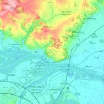
Name: Mauthausen topographic map, elevation, terrain.
Location: Mauthausen, Bezirk Perg, 4310, Österreich (48.23099 14.48906 48.26203 14.58360)
Average elevation: 275 m
Minimum elevation: 235 m
Maximum elevation: 388 m
Die komplette Liste der Statistik Austria ist in: Topographische Siedlungskennzeichnung nach STAT
Other topographic maps
Click on a map to view its topography, its elevation and its terrain.
Waging
Österreich > Bezirk Perg > Oberzirking
Waging, Oberzirking, Ried in der Riedmark, Bezirk Perg, 4312, Österreich
Average elevation: 291 m