
Thank you for supporting this site ❤️
Make a donation
Make a donation
Distrito Potrerillos topographic map
Click on the map to display elevation.
Thank you for supporting this site ❤️
Make a donation
Make a donation
About this map
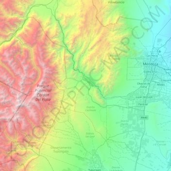
Name: Distrito Potrerillos topographic map, elevation, terrain.
Average elevation: 2,198 m
Minimum elevation: 645 m
Maximum elevation: 5,876 m
Thank you for supporting this site ❤️
Make a donation
Make a donation
Other topographic maps
Click on a map to view its topography, its elevation and its terrain.
Luján de Cuyo
Argentina > Mendoza > Departamento Luján de Cuyo > Luján de Cuyo
Average elevation: 951 m