
Make a donation
Paraná topographic map
Click on the map to display elevation.
Make a donation
Paraná
The state can be separated into five main topographic areas, from east to west: a coastal zone, the mountains of Serra do Mar, and then three plateaus, each lower than the other, until the Paraná River is reached.
Make a donation
About this map
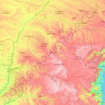
Name: Paraná topographic map, elevation, terrain.
Location: Paraná, South Region, Brazil (-26.72090 -54.61986 -22.51600 -47.85611)
Average elevation: 548 m
Minimum elevation: -1 m
Maximum elevation: 1,585 m
Make a donation
Other topographic maps
Click on a map to view its topography, its elevation and its terrain.
Amazon River
During what many archaeologists called the formative stage, Amazonian societies were deeply involved in the emergence of South America's highland agrarian systems. The trade with Andean civilizations in the terrains of the headwaters in the Andes formed an essential contribution to the social and religious…
Average elevation: 5 m
Amazon River
During what many archaeologists called the formative stage, Amazonian societies were deeply involved in the emergence of South America's highland agrarian systems. The trade with Andean civilizations in the terrains of the headwaters in the Andes formed an essential contribution to the social and religious…
Average elevation: 4 m
Make a donation
Jardim Copacabana
Brazil > São Paulo > Região Metropolitana de São Paulo > São Paulo
Average elevation: 792 m
Rio de Janeiro
Brazil > Rio de Janeiro > Região Metropolitana do Rio de Janeiro > Rio de Janeiro
Temperature also varies according to elevation, distance from the coast, and type of vegetation or land use. During the winter, cold fronts and dawn/morning sea breezes bring mild temperatures; cold fronts, the Intertropical Convergence Zone (in the form of winds from the Amazon Forest), the strongest…
Average elevation: 40 m
Make a donation