
Boyacá topographic map
Interactive map
Click on the map to display elevation.
About this map
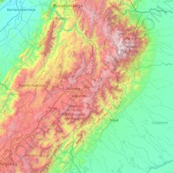
Name: Boyacá topographic map, elevation, terrain.
Location: Boyacá, Colombia (4.65581 -74.65933 7.05484 -71.94602)
Average elevation: 1,403 m
Minimum elevation: 63 m
Maximum elevation: 5,144 m
Other topographic maps
Click on a map to view its topography, its elevation and its terrain.
Villa de Leyva
Colombia > Boyacá > Villa de Leyva
Villa de Leyva, Boyacá, 15401, Colombia
Average elevation: 2,673 m