
Way Haru topographic map
Interactive map
Click on the map to display elevation.
About this map
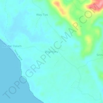
Name: Way Haru topographic map, elevation, terrain.
Location: Way Haru, Pesisir Barat, Lampung, Sumatra, Indonesia (-5.76690 104.43976 -5.72690 104.47976)
Average elevation: 19 m
Minimum elevation: 0 m
Maximum elevation: 121 m
Other topographic maps
Click on a map to view its topography, its elevation and its terrain.
Gunung Pugung
Indonesia > Lampung > Pesisir Barat
Gunung Pugung, Pesisir Barat, Lampung, Sumatra, Indonesia
Average elevation: 1,318 m